Science of green exploration|

GeoResonance is a provider of unique geophysical surveys.
We can search for any commodity. Anywhere. Fast.
LEARN MORE

GeoResonance surveys

Unambiguous results.
Extraordinary depths.

We are a multinational geophysical survey company. With over 25 years of experience in geophysical surveys, we offer our clients a unique and proven methodology of subsurface exploration.

GeoResonance technology unmistakably identifies subsurface substances by their characteristic Spectral Signatures. Our surveys are unambiguous, fast and cost-effective.

Remote Sensing Survey

Remote Sensing

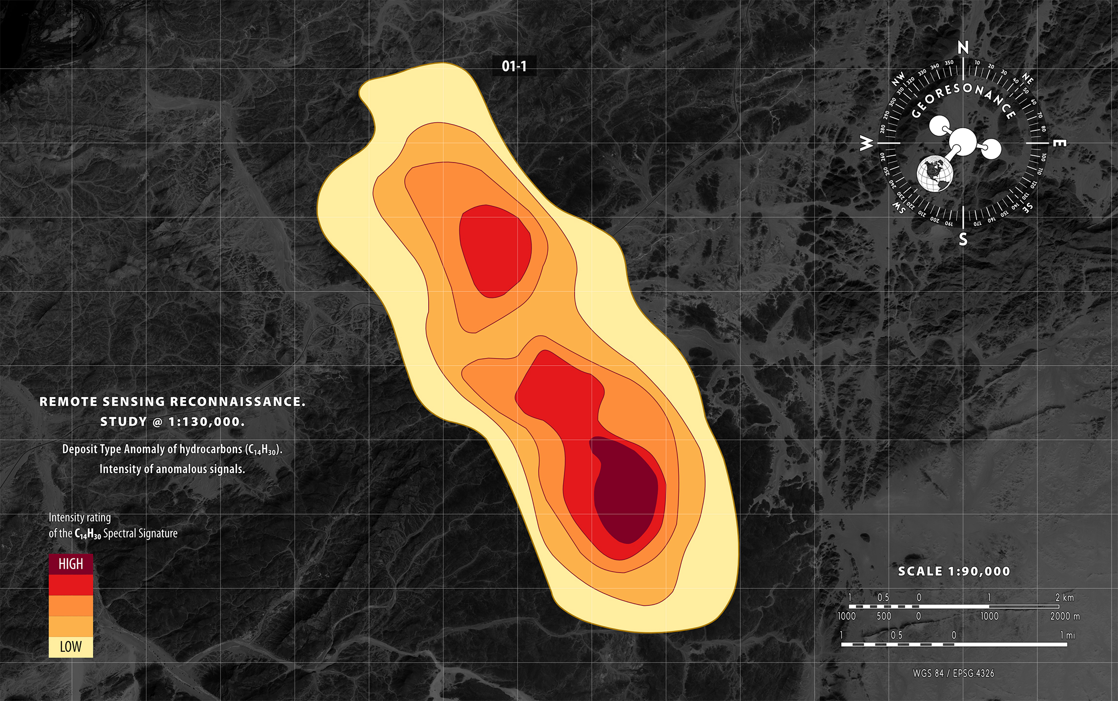
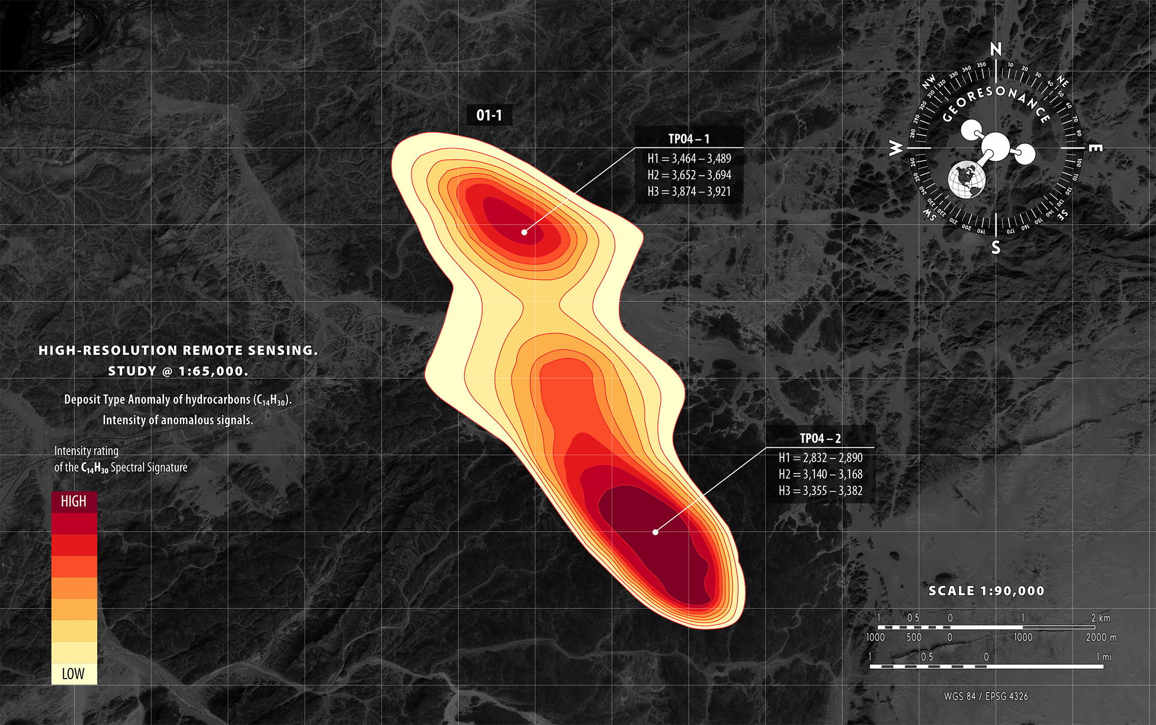
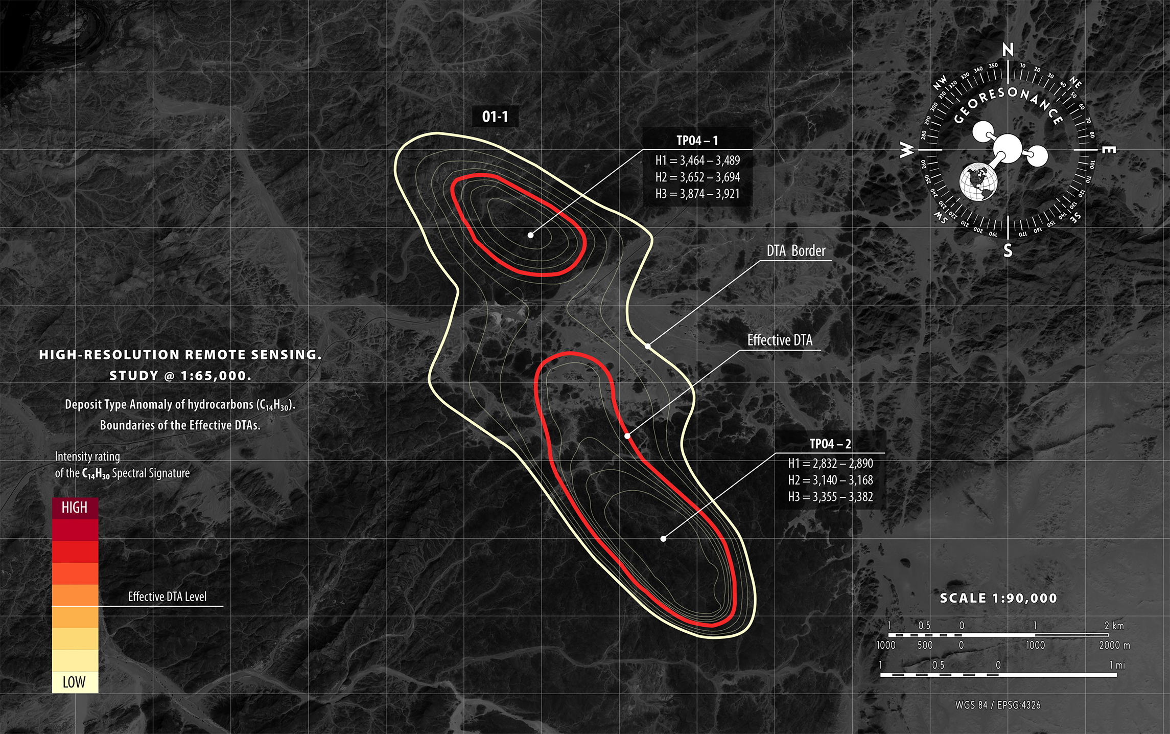
GeoResonance Remote Sensing Surveys are based on the proprietary processing of satellite multispectral images of a given study area. Vast territories can be comprehensively surveyed within weeks.

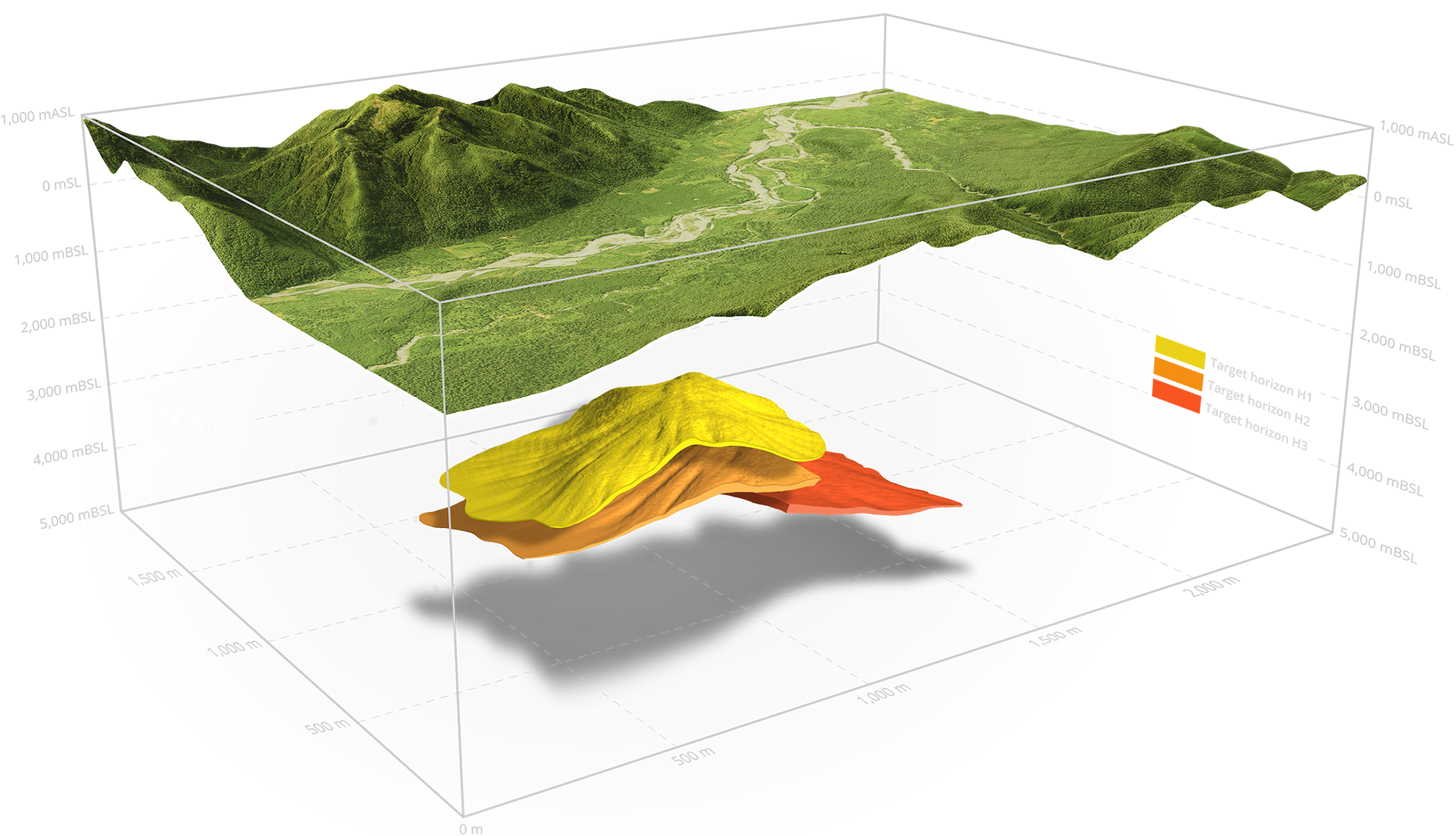
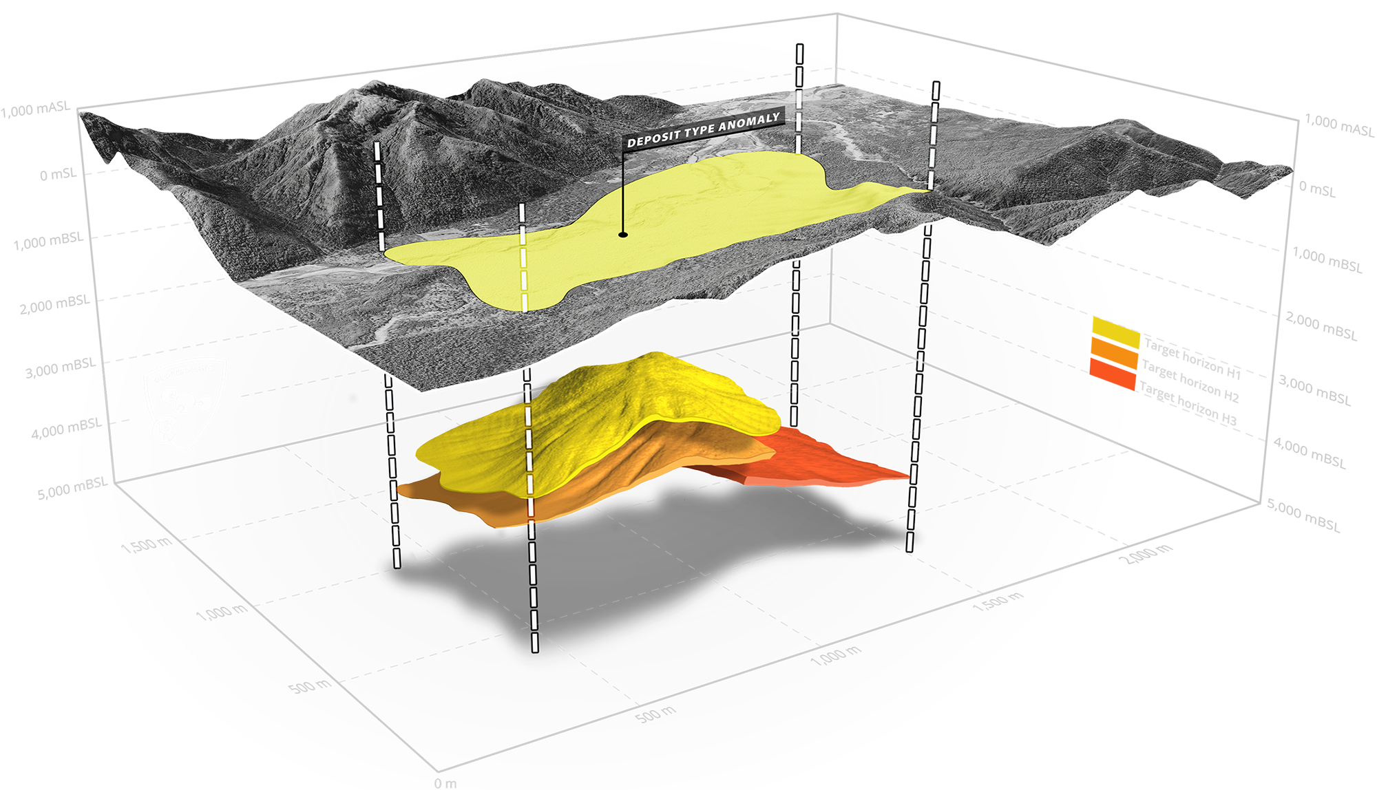
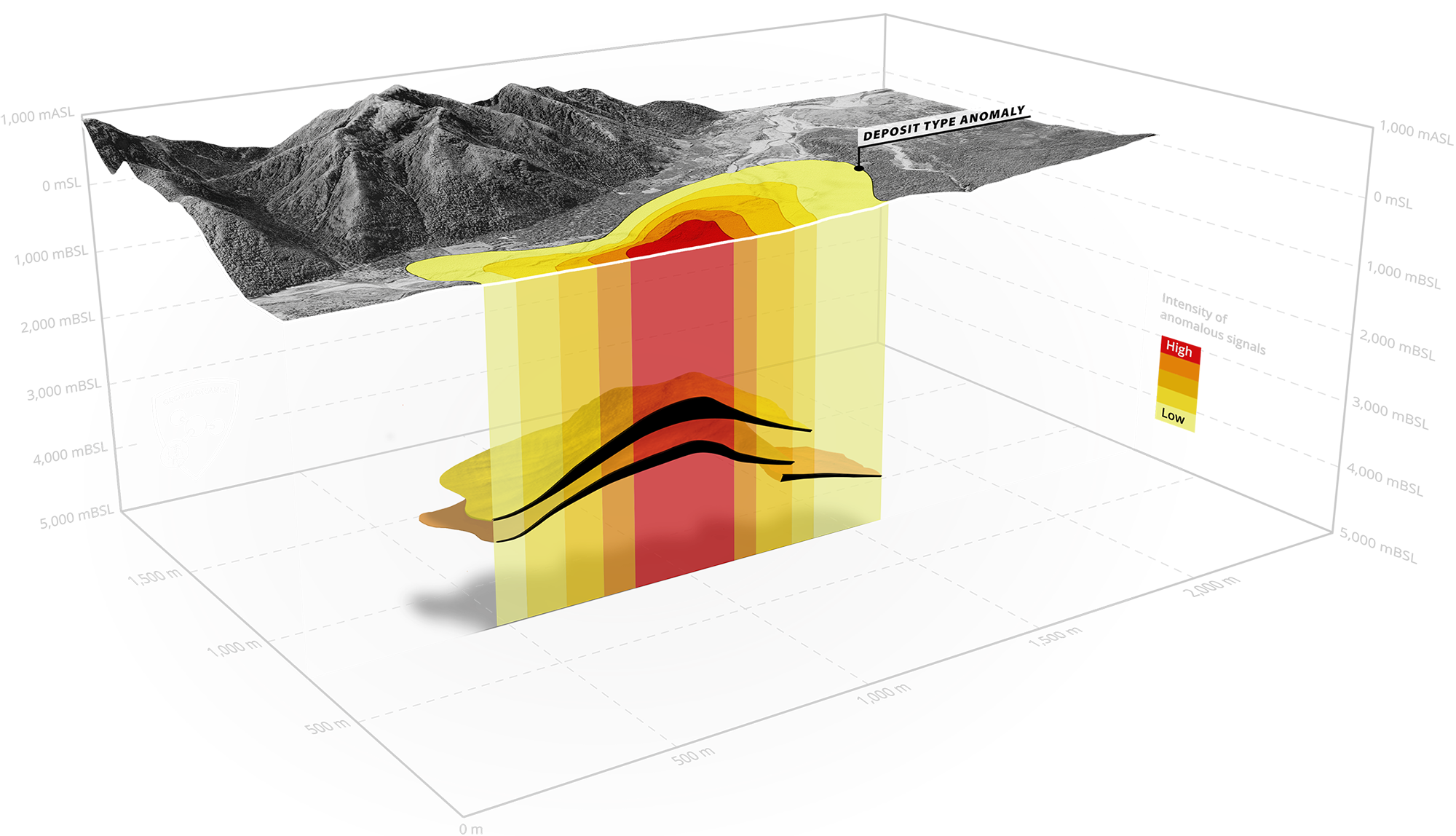
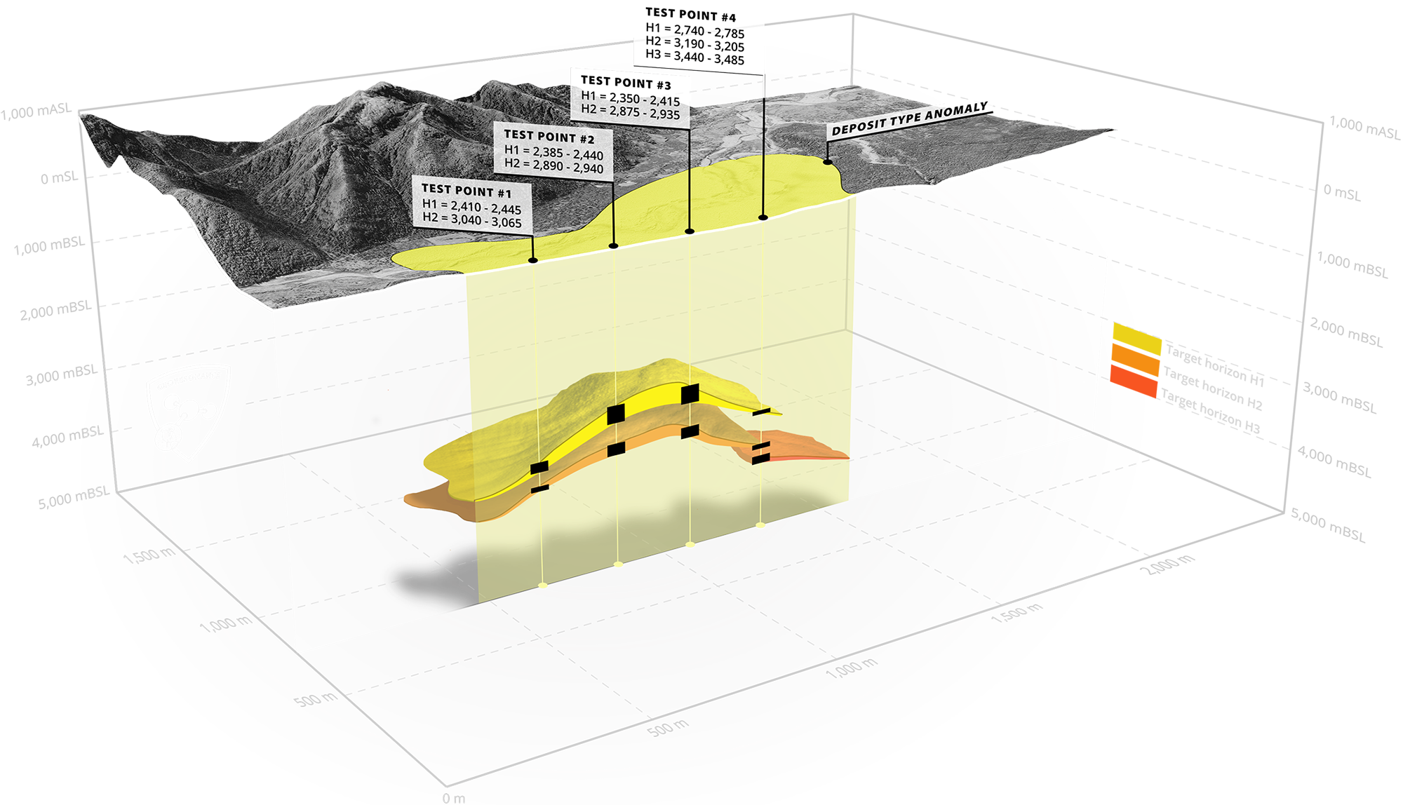
Our Remote Sensing Surveys reliably identify hydrocarbon deposits and aquifers to depths of 5,500 metres (18,000 feet), and mineral deposits to depths of 1,500 metres (5,000 feets).

On-Site Survey

On-Site Survey

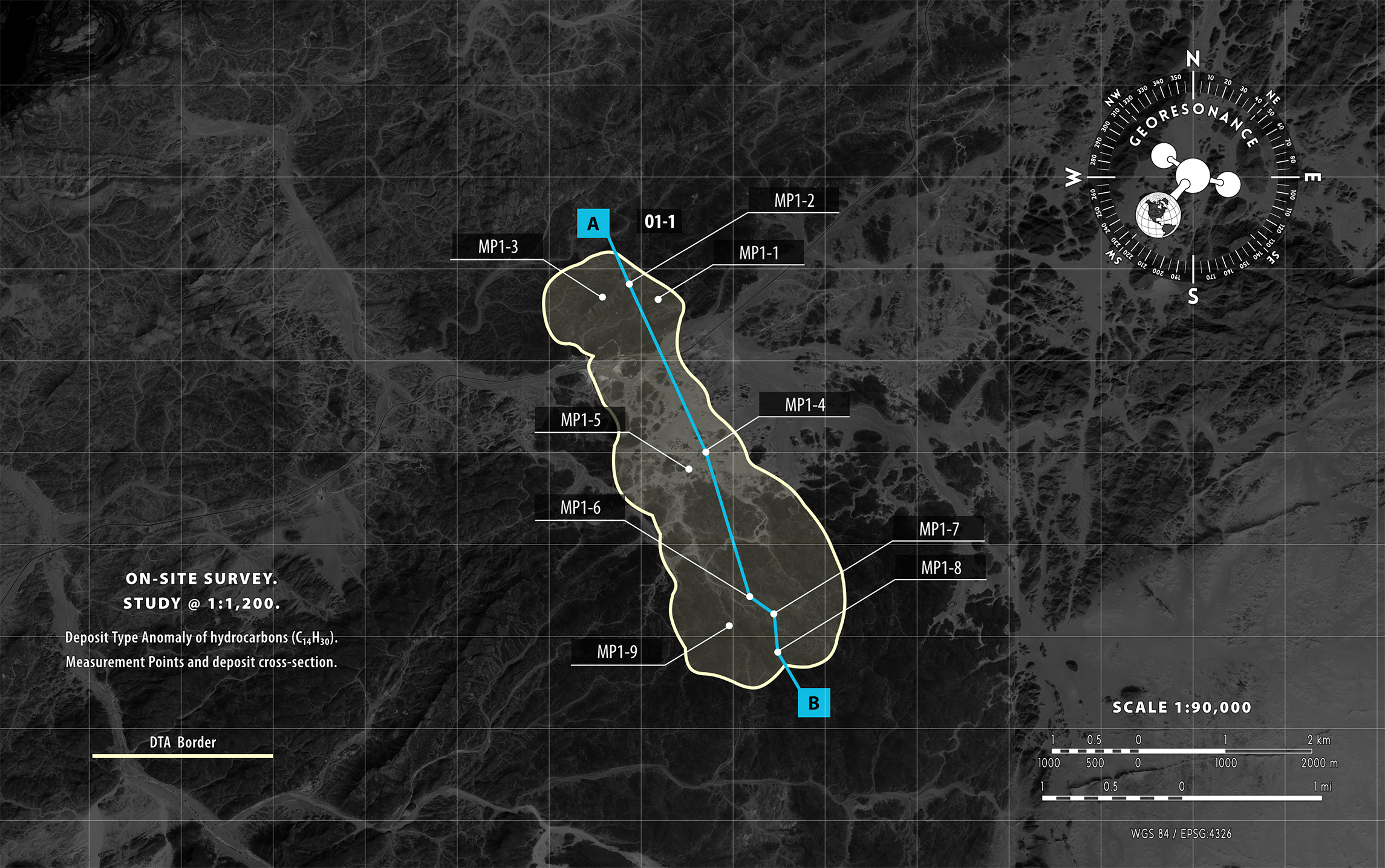
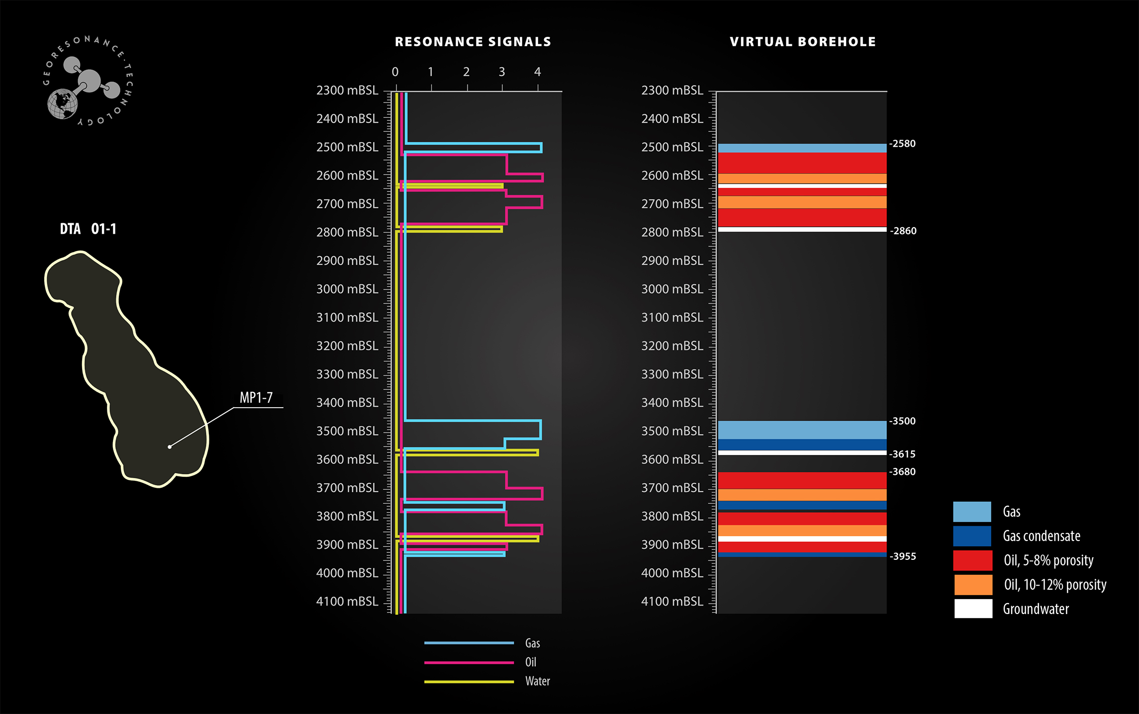
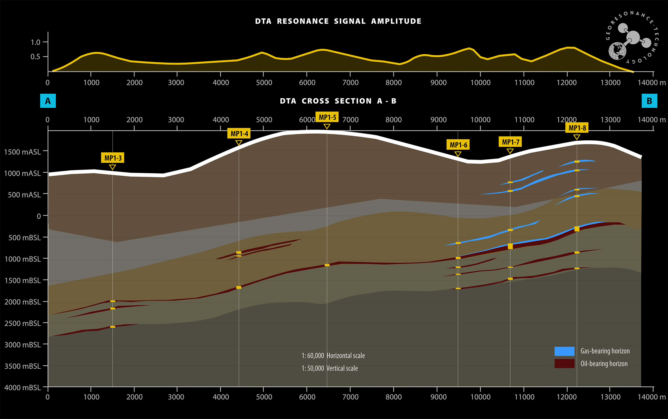
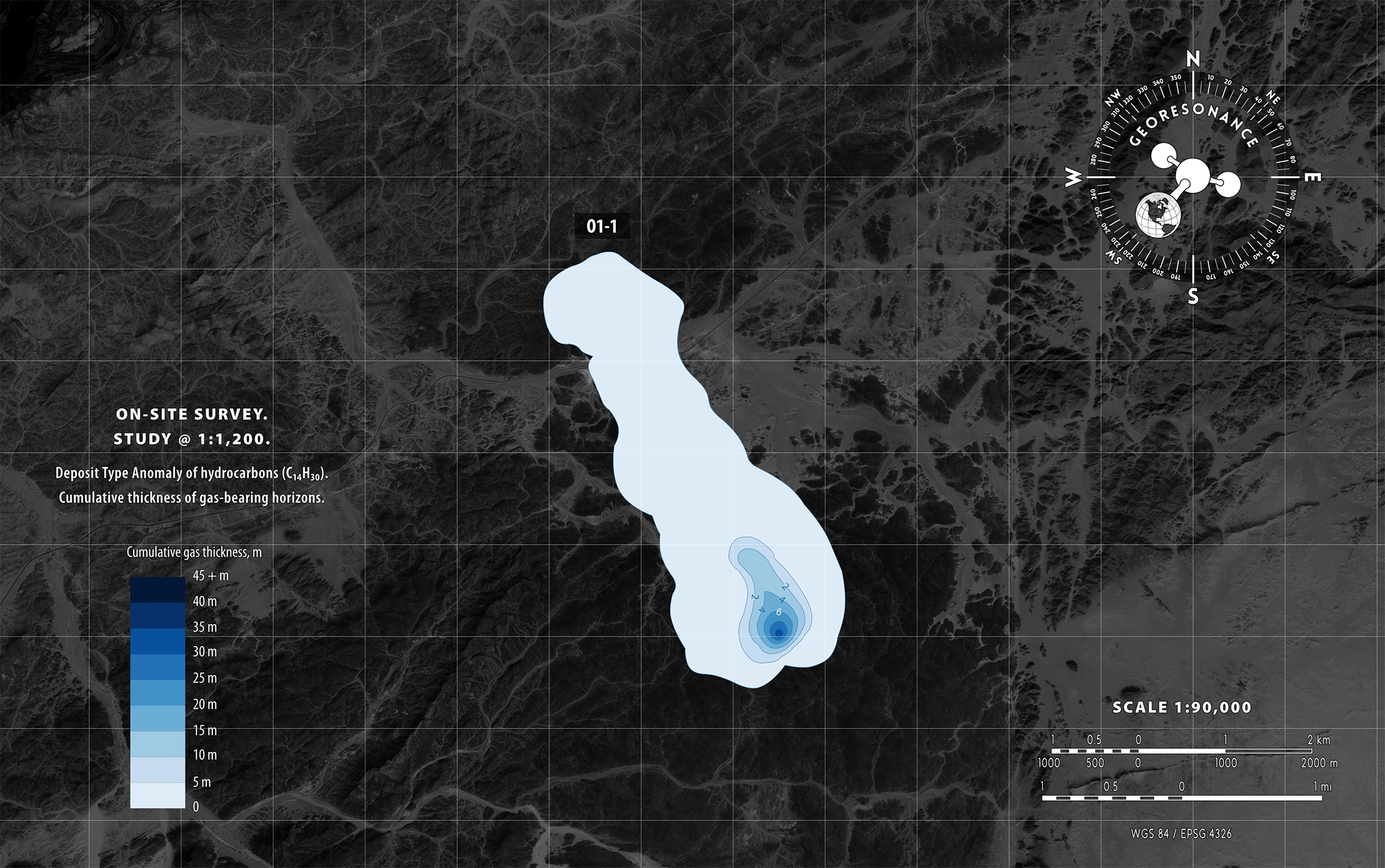
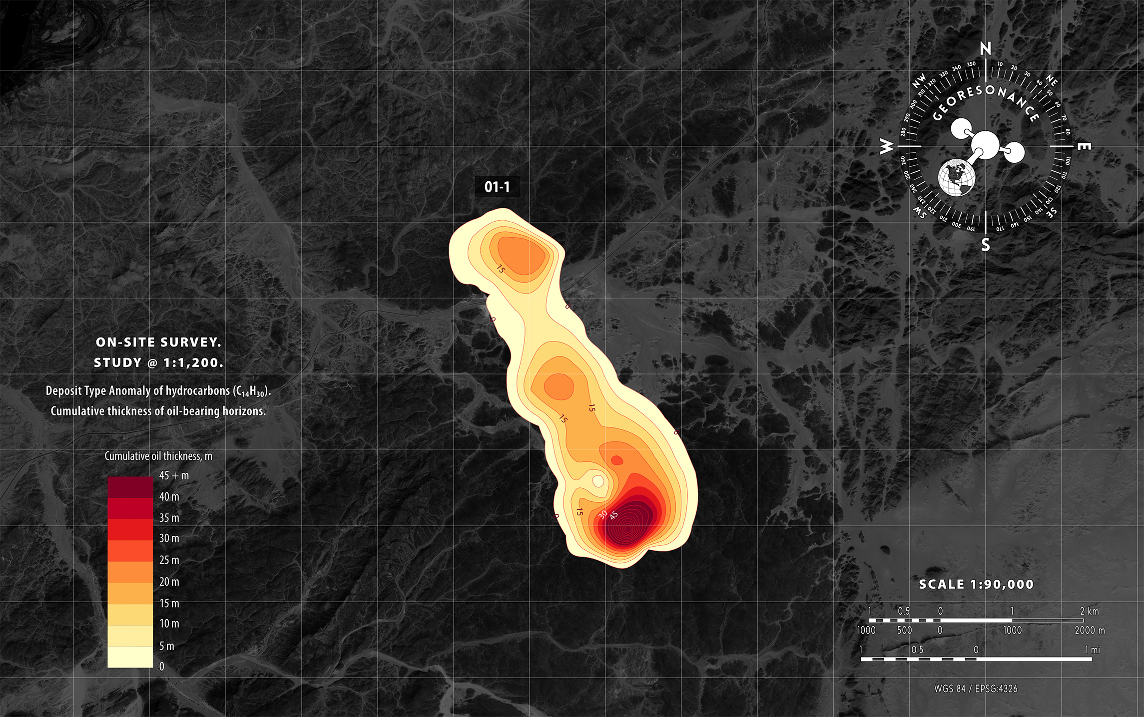
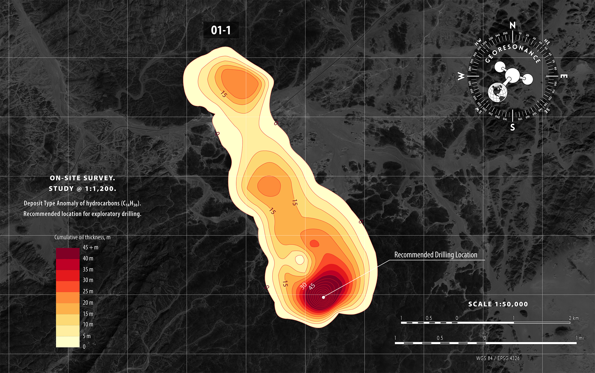
GeoResonance On-Site Surveys accurately measure the occurrence depths of targeted substances, estimate in-ground resources, and establish locations for drilling exploratory wells, among other valuable insights.

Our measurements do not require interpretation. If the targeted substance is present, we detect its Spectral Signature above the surface.

Unmatched exploration tool
GeoResonance Remote Sensing Survey of 1,000 km2 may take only 7 weeks.

Projects Geography

Five continents.
One technology.

We have surveyed over 157,200 km2 in 30 countries. We are ready for any survey conditions. Onshore and offshore. High and low. Hot and cold.

Learn More About Our Projects
Science creates solutions
GeoResonance combines over 20 technologies and patented know-hows into one methodology.

Direct identification

Find more.
Drill less.

Traditional geophysical surveying methods are prone to major ambiguities and uncertainties of interpretation. In contrast, GeoResonance provides a rapid, cost-effective, and unambiguous alternative based on the direct identification of deposits.

With GeoResonance, you will maximise the rate of ground coverage and minimise drilling requirements.

GeoResonance direct identification GeoResonance petroleum anomaly GeoResonance intensity of anomalous signals GeoResonance Remote Sensing Test Points
GeoResonance determines the molecular structure of subsurface materials by analyzing their characteristic resonance spectrum, also known as the Spectral Signature. When the targeted Spectral Signature is detected above the earth's surface, it provides direct identification of the subsurface deposit.
The primary objective of GeoResonance surveys is to identify and study Deposit Type Anomalies of targeted substances. A Deposit-Type Anomaly (DTA), also referred to as an anomaly or anomalous zone, is an area on the surface of the earth where the Spectral Signature of the targeted substance has been registered. A DTA is a cumulative projection of one or several subsurface deposits on the surface of the earth.
GeoResonance analyses the intensity of Spectral Signatures, which are anomalous signals that indicate the presence of targeted substances. Higher intensities of these signals may suggest higher volumes of the substance, shallow occurrence depths, or both. Using a colour-coded map, GeoResonance presents a clear visual representation of the spatial distribution and concentration of the substance based on the intensity of the anomalous signals.
GeoResonance determines the True Vertical Depths to the top and bottom of subsurface target-bearing intervals at specific locations within identified anomalous zones. These locations are referred to as "Test Points" during a Remote Sensing Survey and "Measurement Points" during an On-Site Survey.
Learn More About Our Technology
With great data comes great capability
Geoscience of the 21st century to keep you one step ahead.

Reports

Comprehensive.
Unambiguous.
Decision-ready.

Our reports are based on the direct identification of targeted substances. Learn the potential of your area of interest before you drill. Save time and money.

Learn More About Our Technology

Technology Applications

Just what you need.
Just ask GeoResonance.

We understand the risks and costs of exploration. We will create value for your project by ensuring that all viable prospects are identified. We will minimise your losses by halting your efforts on a project that is either technically infeasible or economically unviable.

Archaeological
Investigations

The GeoResonance technology excels in detecting and accurately locating buried wood, stone, and metal artefacts of any size. It can also map ancient walls and foundations, detect and map subsurface cavities, and inspect the structural integrity of ancient structures.

Hydrogeological Studies

GeoResonance technology accurately maps aquifers of geothermal water and groundwater down to 1,500-3,000 m (5,000-10,000 ft) depths.

GeoResonance Remote Sensing reliably identifies groundwater horizons, determines their occurrence depths, estimates water temperature and its chemical characteristics (fresh water or salt water), determines the direction of groundwater migration.

GeoResonance On-Site Surveys determine the chemical composition of groundwater, water temperature, render Virtual Boreholes and cross-sections, select locations for drilling water bores, and estimate the potential water debit.

Greenfield reconnaissance

Before your company bids for an exploration license, GeoResonance Remote Sensing can accurately identify the presence of economically viable mineral and hydrocarbon deposits in your area of interest.

Large-scale Remote Sensing surveys can be undertaken in deserts and forests, where vehicle access is impractical, or in mountainous areas where access would be impossible.

By combining the GeoResonance Remote Sensing survey with the GeoResonance On-Site Survey, your exploration program can be significantly shortened and the associated financial risks can be reduced.

Petroleum Exploration

GeoResonance technology reliably identifies Deposit Type Anomalies of hydrocarbons both onshore and offshore.

Through the use of Remote Sensing, GeoResonance accurately determines the locations, boundaries, and number of hydrocarbon-bearing pay zones, as well as the depths of their occurrence, down to 5,500 m (18,000 ft).

With On-Site Surveys, GeoResonance quantifies characteristics of hydrocarbon deposits and estimates the Petroleum-Initial-In-Place. Additionally, the technology helps to identify optimal locations for drilling wells.

Mineral Exploration

GeoResonance technology is an unmatched exploration tool for direct identification of mineral deposits.

Our Remote Sensing maps the locations and boundaries of targeted mineral deposits, determines occurrence depths of ore bodies down to 1,500 m (5,000 ft), and provides recommendations for subsequent core drilling programs.

GeoResonance On-Site Surveys accurately measure quantitative characteristics of mineral deposits, delineate mineralisation zones, estimate Inferred Mineral Resources, and identify optimal drilling locations for sampling and exploration.

Drilling Support

GeoResonance technology minimises the risk of drilling a dry hole and ensures that an exploration well is positioned within an economic hydrocarbon deposit.

By accurately mapping subsurface occurrences of hydrocarbons, GeoResonance also reports locations of aquifers, as well as oil-water and gas-water contacts.

Tell Us About Your Project
Protecting the Green in our blue planet
Developing the Earth needs to be done responsibly.
Become a forerunner of sustainable exploration with GeoResonance.

Green Exploration with GeoResonance

Green Technology.
By Design.

Exploration and mining activities can have significant impacts on the atmosphere, landscape, lithosphere, and hydrosphere. Traditional exploration methods often involve destructive practices such as clearing vegetation, producing noise pollution and vibrations, and contaminating aquifers through drilling and fluid disposal.

The GeoResonance technology was designed to have zero environmental impact while also helping the industry to reduce the environmental impacts associated with the extraction and processing of hydrocarbons, metals, and minerals.

Threats

Water scarcity. Water is one of the greatest constraints to new supply of mined products across the industry. Quality and availability of water are drivers for those water-related social conflicts with mining companies.

Water pollution. Groundwater aquifer contamination through drilling and fluid disposal. Surface water contamination by mine water. Surface water contamination by chemical agents used in processing ores.

What we do

Remote Sensing Reconnaissance to map groundwater resources in vast territories.

Determine the chemical composition of groundwater to identify fresh water aquifers.

Conduct a groundwater survey within drilling locations, to ensure that drilling and production do not contaminate the water-bearing strata.

Detect pollution plumes in groundwater systems.

Determine the direction of flow of groundwater.

Learn More About Our Services

Threats

Soil disturbance and distraction of vegetation by exploration activities such as cutting of traverses, trenching and drilling, mine construction and mine development

Noise hazard and vibration caused by seismic exploration, plants, machinery, blasting and drilling activities.

Soil and rock contamination by heavy metals.

Soil erosion, subsidence, landslides, quakes due to alterations in the equilibrium of the geological environment.

What we do

During GeoResonance surveys, we ensure zero impact on soil and vegetation, minimizing disturbance to the environment.

To minimize impacts on the lithosphere, we eliminate barren territories from exploration, remove sub-economic prospects, and localize exploration and mining activities to economically viable prospects.

We select optimal locations for exploratory wells to minimize disturbance caused by drilling.

Prior to mine construction, we can identify heavy metals in the subsurface to minimize environmental contamination.

Our services include mapping superficial unconsolidated deposits that are responsible for gully erosion and determining the causes of landslides and other hazardous movements of superficial materials.

We specialize in detecting underground cavities and monitoring the integrity of foundations for major engineering structures.

Learn More About Our Services

Threats

Unsustainable exploitation of non-renewable resources, compromising the ability of future generations to meet their own needs.

Unbalanced mining due to the lack of knowledge about the present mineral and hydrocarbon assets.

What we do

We specialise in mapping strategic mineral and hydrocarbon deposits in vast territories to help clients identify potential resources and plan exploration and exploitation activities.

Our Mineral Assets Valuation and Evaluation Program enables nations to plan the balanced and sustainable exploitation of natural resources by providing a comprehensive assessment of mineral assets and their economic value.

Learn More About Our Services

Threats

High costs of exploration and mining due to ambiguous exploration methods.

High costs due to the enormity of unexplored and underexplored territories.

What we do

GeoResonance drastically cuts exploration costs by:

reducing the scope of expensive traditional geophysical surveys;

reducing exploration timelines;

eliminating ambiguities;

focusing exploration on most economically viable natural deposits;

halting or redirecting further effort on a project that is either technically infeasible or economically unviable in its proposed configuration.

Learn More About Our Services

Contact Us

Thanks for your interest in GeoResonance technology. Please use this form if you have any questions about our services and we will get back to you very soon.